
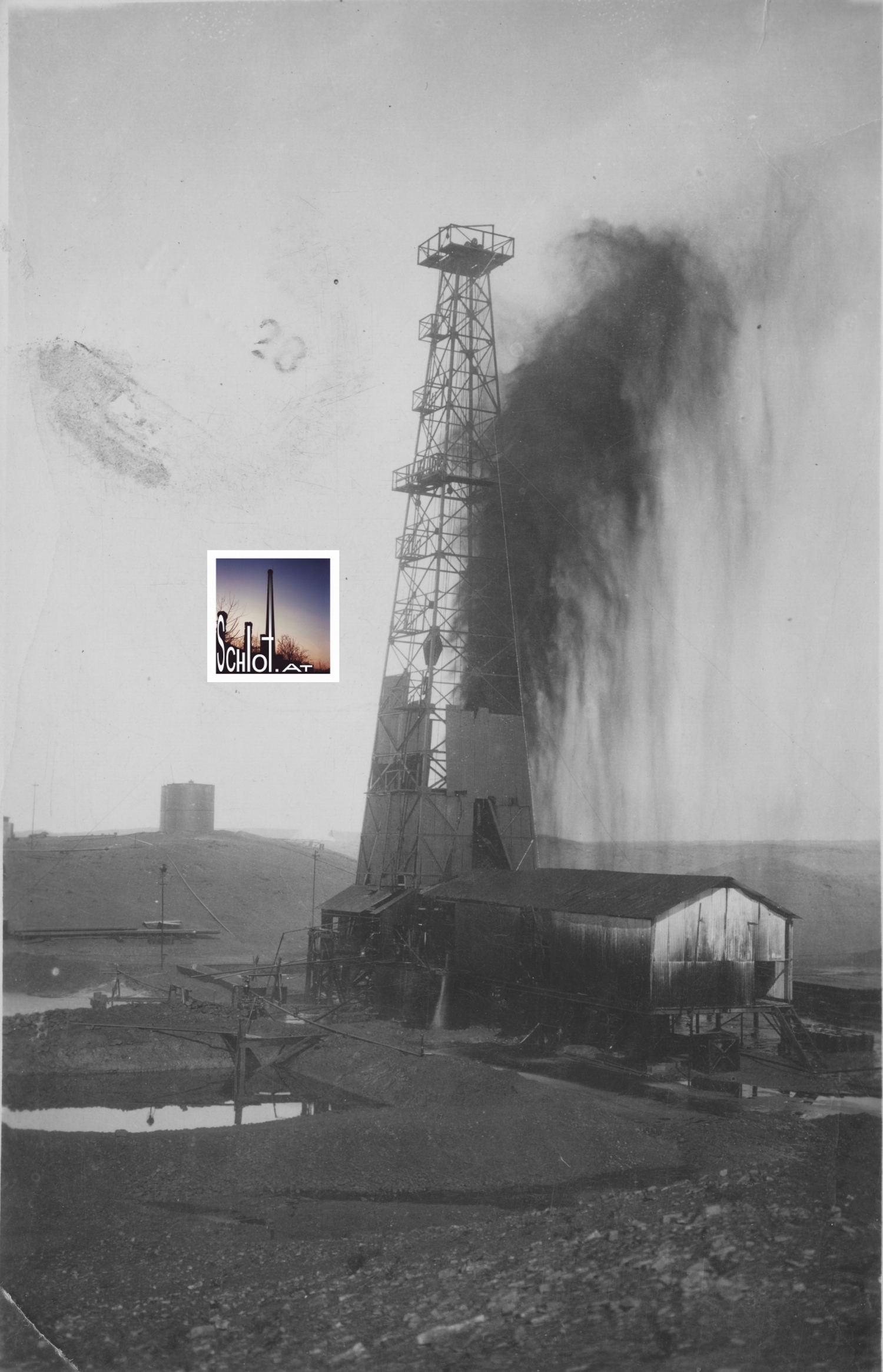
1927 wurde im Nordirak an der Grenze zu den dortigen Kurdengebieten nach Öl gebohrt. Im Ölfeld Baba Gurgur بابا كركر nahe der Stadt Kirkuk wurde man 1927 fündig und erbohrte eine Ölquelle, die bis heute eine der bedeutendsten Quellen des Irak darstellt. Erst zehn Tage nach der Erschließung der Quelle konnte die abgebildete Öleruption mittels Pumpeninstallation kontrolliert werden, bis dahin wurde das umliegende Wadi mit einer bedeutenden Menge Erdöls kontamininiert. Die Reinigungsarbeiten dauerten bis Ende 1927 an [1].
Die oben gezeigte Echtfoto-Postkarte [2] kam ohne Kenntnis der fotografierten Örtlichkeit ins schlot-Archiv. Sie ist rückwärtig mit osmanischem Text beschriftet. Aufgrund der Vermutung, es handle sich um einen osmanischen Text, wurden seitens schlot.at Fr. Dr.Gisela Procházka-Eisl [3] und Fr. Dr. Claudia Römer [4] vom Institut für Orientalistik der Universität Wien zu dem Karteninhalt mittels Scan-Übermittlung um Übersetzungshilfe ersucht.
Sie gaben zu dem Geschriebenen an: "Türkiye – Izmir", vielleicht noch ein "doktor"; und rechts samimi (?) hürmetlerimi takdim ederim, was in etwa (aufrichtig, herzlich) "hochachtungsvoll" heißt." Weiters konnte letzterer Satz um den Absendeort komplettiert werden: "Kerkükden samimi hürmetlerimi takdim ederim" (Ich entbiete meine aufrichtige Ehrerbietung aus Kirkuk). [3] [4].
Über Internet-Recherche konnte seitens schlot.at mit diesem Wissen festgestellt werden, dass der auf der Postkarte gezeigte Bohrturm mit dem Bohrturm im Ölfeld Baba Gurgur identisch ist. Man vergleiche die Beschädigungen an der hölzernen Bohrturmverkleidung.

Quellen:
[1]…Baba Gurgur, abgefragt am 17.06.2015
[2]…Postkarte 129×83 mm Belichtungsfläche, datiert mit 11.11.1929, gelaufen jedoch am 11.11.1928, Eigentum schlot.at-Archiv seit 05/2015
[3]…Danke an A.o.Univ.Prof.Mag. Dr. Gisela Procházka-Eisl, Institut für Orientalistik der Universität Wien
[4]…Danke an A.o.Univ.Prof. Mag. Dr. Claudia Römer, Institut für Orientalistik der Universität Wien
USA | PA | Warren | Wilburine Oil Company | 1926
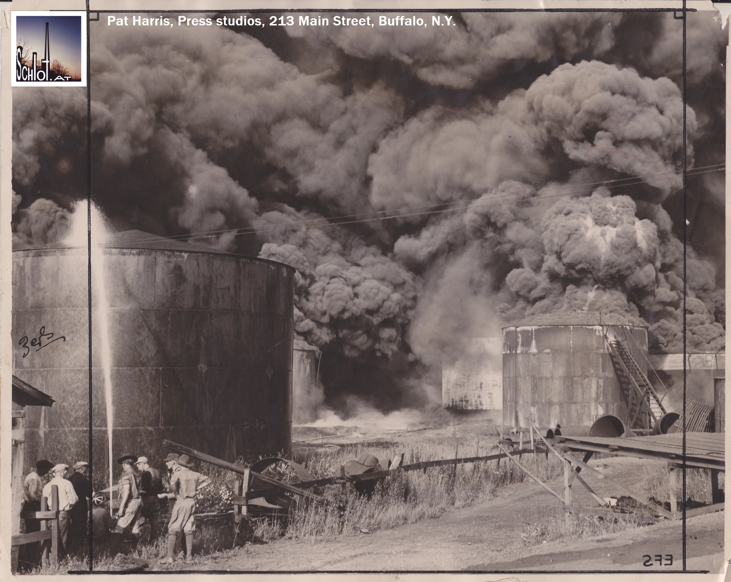
Pressefoto [1] vom 06.08.1926 aus Warren, Pennsylvania. Es zeigt einen am Freitag, den 06.08.1926, durch Blitzschlag verursachten Raffineriebrand am Areal der Wilburine Oil Company. Das Foto verdeutlicht die Machtlosigkeit der Löschkräfte bei einem Kerosin– und Benzinbrand sowie interessante brandtechnische Details (Schwelverhalten). Details zur Erdölförderungsgeschichte von Warren finden sich hier.
Anbei der Originaltext einer leider nicht zitierten amerikanischen Lokalzeitung, der am Fotorevers affichiert ist:
“Fire sweeps oil tanks at Warren
—
Bolt strikes refinery; flames spreading through field
—
Second terrible blaze in month
—
Firemen fighting hard; loss so far $150,000
—
Warren, PA., Aug. 6, 1926-Warren this evening is facing the second terrible oil refinery fire within a month as flames are now tearing their way through the plant and tank field of the Wilburine Oil Co., inside the borough limits.
The fire started this afternoon whne lightning hit a refuse tank in side the working yard of the refinery plant at the foot of Cedar street. Flames immediately envelopped the tank and a fire alarm drew out of the apparatus. The flames spread from the tank, spread to the pump house and hose house of the refinery, envelopping both with flames and effectually shutting off prospects of pumping oil out of the tanks.
Ten tanks are now ablaze and burning. The tank first struck contained twenty-three feet of gasoline and the bolt knocked the bottom out of the tank allowing the contents to escape and the flaming stream surrounded out tanks near; a big storage house containing four big tanks of kerosene was set ablaze and burned.
Every piece of apparatus in the city is now on the scene and scores of firemen from neighboring refining plants are at work in an endeavor to stop the progress of the fire. The loss so far is more than $ 150,000.”
Quelle:
[1] Pressefoto von Pat Harris, Press studios, 213 Main Street, Buffalo, N.Y. (1926), originale Tuschemarkierungen und Schneidmarken für Reproduktion am Papier; Archivbestand schlot.at (2014)
USA | NY | Brooklyn Borough Gas Works, 1921


Luftbild aus 1921 [1], Ausschnitt des ehemaligen Brooklyner Gaswerkskomplexes, Nähe Luna Park (Vergnügungspark) auf Coney Island, Stadt New York. Das Gaswerk wurde von 1908 bis in die 1960 er Jahre betrieben [2, S 4 ff]. Teile des Geländes wurden ab 2001 einer Altlastensanierung unterzogen. Die gaswerksüblichen Grundwasserkontaminanten BTEX und PAK waren Anlaß der Sanierung [2].
Quellen:
[1]…Luftbildabzug 6295 der Atlantic-Photo-Co Berlin. Foto vom 02.11.1921. Eigentum schlot.at-Archiv
[2]…Projektdarstellung Sanierung BBGW (2001), Department of Environmental Conservation, abgefragt am 11.06.2013